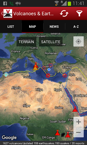
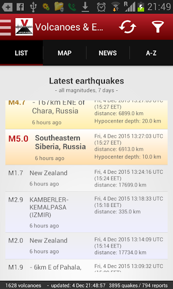
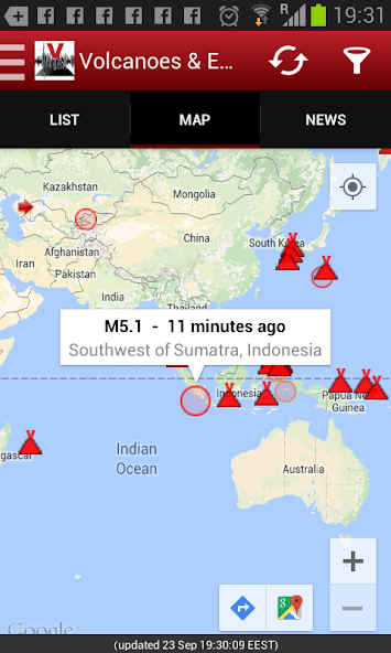
Shows recent earthquakes and active volcanoes on map or list, volcano info/news.
Volcanoes & Earthquakes shows the latest earthquakes worldwide or only quakes near you, as well as earthquake "I-felt-it" reports for earthquakes, in near real-time. It also shows active volcanoes on a map and as a list, along with volcano news from all the world.
You can filter and display the data in various ways, for example by magnitude or age of earthquakes, distance from your location, volcano status and much more.
SUPPORT US!
If you like the app, please write us a 5-star review to support our premium ranking, which in turn will help us to keep on improving the app and developing it further. More features and upgrades are planned!
Features:
- See currently erupting volcanoes on a map (more than 1600 active and dormant volcanoes)
- Get most recent volcano news, including volcanic ash advisories (starting from v.1.4.0)
- See the most recent earthquakes around the world based on one of the most complete and accurate earthquake datasets on the internet – earthquakes worldwide up to 7 days old
- Notifications: near-real time earthquake & volcano alerts
- Custom alerts for user-set locations/areas
- Detailed tectonic plates
- 1000s of active faults
- Alert if earthquakes might have been felt in your area
- Larger earthquakes (above magnitude 6.0) available for up to 1 year
- Listing of earthquakes near active volcanoes (could indicate volcanic unrest)
- Complete volcano listing worldwide alphabetically/by country/by activity level (starting from v. 1.4.0)
- Multiple data sources (more than 40 international and national data sources)
- Filter earthquakes according to magnitude, age and distance
- Filter quakes by continent, country or state (starting from v. 2.3.0)
- Sort quakes by time (latest) or size (magnitude)
- Earthquake archive since 2012 - arguably the most complete available on the web (starting from v. 2.3.0)
- Earthquake stats – magnitude/energy/depth vs time or magnitude (starting from v. 2.4.0)
- Submit/read/view user earthquake reports on map via the "I felt an earthquake" feature
- Detailed information about each earthquake
- Detailed information about each volcano including list of eruptions and manner of eruptions
- Tectonic plate boundaries
- Purpose-built and customized, highly compressed data format to save bandwidth
- Optional automatic background loading of data
- Submit a feature request through comments!
Upcoming features:
- More data sources to be added
- Earthquake news
Main earthquake data sources currently used:
- British Geological Survey (BGS), UK
- China Earthquake Information Centre (CEIC), China
- Russian Academy of Science (Камчатский филиал Геофизической службы - EMSD), Russian Federation
- European-Mediterranean Seismological Centre (EMSC), France
- National Geographic Institute (Instituto Geográfico Nacional - IGN), Spain
- Icelandic Met Office (IMO), Iceland
- National Institute of Geophysics and Volcanology (Istituto Nazionale di Geofisica e Vulcanologia - INGV), Italy
- Geoscience Australia (GeoAu)
- New Zealand Earthquake Commission and GNS Science (GEONET), New Zealand
- German Research Centre for Geosciences (Deutsches GeoForschungsZentrum Potzdam – GFZ), Germany
- National Seismological Center of the University of Chile (Centro Sismológico Nacional, Universidad de Chile – GUG), Chile
- Kandilli Observatory and Earthquake Research Institute-Regional Earthquake and Tsunami Monitoring Center (KOERI-RETMC/BOUN KOERI), Turkey
- Natural Resources Canada (NRCAN), Canada
- Philippine Institute of Volcanology and Seismology (PHILVOLCS), Philippines
- Swiss Seismological Service (Schweizerischer Erdbebendienst. SED), Switzerland
- Servicio Sismológico Nacional (SSN), Mexico
- United States Geological Survey - Earthquake Hazards Program (USGS), USA
Disclaimer:
Although we take care to collect data from reputable sources and strive for accuracy, there is no guarantee that the information is correct or complete and that the app will always perform as intended.
Get free Primogems, Mora, Experience, and more with these November 2024 Genshin Impact codes, 5.1 livestream codes, and find out how to redeem active codes.
If you are bored with playing the vanilla version of Metaphor ReFantazio, you can check out these five mods.
Struggling with your submissions for Roblox's The Haunt event in 2024? Check out our guide on using Dress to Impress to create your captures!
Our walkthrough for Dragon Age: The Veilguard with some handy tips and tricks, with guides for puzzles, bosses, companions, equipment, romance, and more!
Which faction should you pick in Dragon Age: The Veilguard?
Looking for some bonus resources in Sea of Conquest: Pirate War? We’ve got you covered with these codes for the latest seafaring freebies.
On our website, you can easily download the latest version of Volcanoes & Earthquakes! No registration and SMS required!